Mine Surveying
The main task of operational mine surveying is the performance of measurements on the surface and underground for the development of underground workings and determination of location and extent of the underground mine-workings and its calculation.
Further, it comprises
- the preparation and updating of drawings and maps for mining purposes (mine plan),
- the exploration, investigation, recording and mapping of deposits,
- the evaluation of the mine plans for identifying potential hazard areas and their graphical representation,
- as well as mine damage matters.
Subject areas
1 Mine plan
1.1 Preparation and updating of the mine plan in accordance with the ordinance on mine surveying (MarkschBergV)
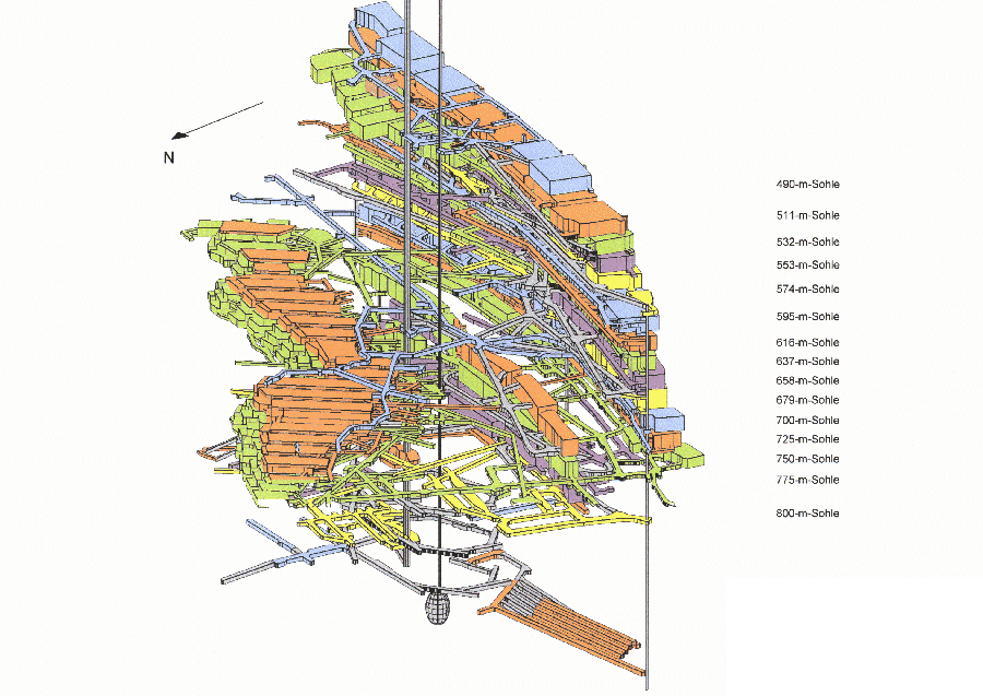
1.2 Development of digital plans for 3D representation of the underground workings and of geology/tectonics as well as development of a Geographic Information System (GIS)

- Asse mine: Simplified 3D representation of the workings structure [for larger view click on image]
- Set-up and maintenance of the hardware
- Set-up and maintenance of the software
- Development of a database
- Representation of the geological-tectonic structure for rock mechanical and hydrogeological model calculations
1.3 Preplanning and implementation planning for mining
2 Deformation measurements
2.1 Analysis for the determination of mine damages
- Subsidence measurements at surface
- Deformation measurements underground in form of extensive position measurements
- Determination of transfer functions for subsidence prediction and prediction on extreme ground movements
2.2 Determination of deformation behaviour of horizontal and vertical pillars as well as of chambers
- Pillar compression
- Lateral strain on pillars
- Horizontal crown deformation
- Face movement
2.3 Summary assessment of the deformation measurements
- Error analysis by compensation
- Deformation analyses
- Determination of deformation at the southern flank
- Reporting to the Federal Institute for Geosciences and Natural Resources (BGR) and the Mining Authority
- Verification of rock-mechanical calculation models
3 Geology / Hydrogeology
3.1 Geological-tectonic investigation
- Mapping of explorations at surface and underground
- Investigation of the geophysical conditions at the preliminary stage from above ground and underground
- Development of the geological-tectonic model
3.2 Hydrogeological monitoring
- Performance and evaluation of the hydrologic measurement program in the course of preservation of evidence
- Sampling and chemical analysis of inflowing saline solutions
- Hydrochemical characterisation of groundwaters and saline solutions at the Asse site
- Development of hydrologically relevant structure models and performance of model calculations
- Clarification of the origin of the saline solution entering the mine – identification of pathways and estimation of the reservoirs